This page serves as the primary resource for editors of Virginia. Review all the sections to better understand how the guidelines for this state might deviate from the overall USA or worldwide guidelines. If you have any comments or questions about this page or state refer to the community links below.
SR < 600 and VA > 600 is official now! Please see this section for more information.
The Mid-Atlantic Region is using Discord as the local communication method!
Join the MAR Discord server here: Discord Invitation
Introduction
Virginia is a part of the Mid Atlantic region, which includes the states and/or territories of:
Before editing the maps in Virginia, be sure to fully review and understand the editing manual.
The Waze user community follows the Waze etiquette guidelines discussed in the Wiki. Be sure to familiarize yourself with these guiding principals while editing the maps and this Wiki, as well as when communicating with other Waze users.
The below map of Virginia includes links to all known GIS mapping utilities for all counties and independent cities in the state. Jurisdictions that do not have a known public GIS system will not link anywhere. See Virginia/Resources for guidance in Virginia that may not be universal to all other states and territories, and any GIS resources (towns, tax assessment) that are not shown on the map below.
The Waze forum is a great place to find answers to previously asked questions and also a place to ask new ones. Below are links to the forums specific to Virginia.
New editors should consider checking into the formal mentoring program available at no charge.
See Virginia/Community for guidance in Virginia that may not be universal to all other states and territories.
Update Requests
An Update Request (UR) is a Map Issue reported by a user from the Waze client app. It is also a layer in the Map Editor. See update requests for more information. VA has a policy of shared UR management. This means that URs are open to all editors and that there is no "ownership" implied when posting the initial comment. However, it is courteous to allow new editors or editors you don't have an informal agreement with an extra day or two to respond to reporter comments and/or post reminders. Effective UR conversations are usually achieved with a single point of contact for the reporter, but other editors can step in if a UR with reporter comments begins to sit idle or if they think another editor needs help. Please be respectful to other editors and reporters while working URs; it is usually best to send a message to the editor rather than chatting with them through a UR. (Most reporters don't care about the chat, they just want it fixed and not be bothered with multiple responses). Typically, an editor should be given some time to respond to the reporter's comments (since real life has a way to occasionally get in the way to prevent editing time on some days).
In Virginia we have adopted at 0/4/4 system for response to Update Requests. 0/4/4 is the short way of explaining the following.
Day 0
The first editor who is able to respond to UR should attempt to resolve the UR. If they are successful, they should comment as such in the UR and mark it closed. If more information from the reporter is required to make progress towards closure, a query should be sent to the reporter requesting the information needed for resolution
Day 4+
Polite reminders should be sent to a reporter who has never responded to a query, provided at least three full days have elapsed since the initial response was sent. (You can send reminder at 00:01 Eastern Standard (or Daylight when applicable) Time on the fourth day).
Example
"If no further information is provided we will be unable to fix the issue you encountered and this report will be closed soon"
Second Day 4+
URs may be noted as closed due to lack of reporter response, provided at least three full days have elapsed since the followup message was sent (You can close at 00:01 Eastern Standard (or Daylight when applicable) Time on the fourth day since the reminder was sent)
Example
"This report is being closed due to lack of information, please submit another report if the issue continues. Happy Wazing!"
If you use URComments then the settings should be 4 for reminder and 4 for closure.
Cities and towns
One of the most common errors when editing the maps is when an editor creates a road and does not confirm the road by setting the city and road name (or stating it has none).
There are 38 independent cities and 95 counties in the state. The city layer in Virginia should be drawn from the 2010 Census Maps, adding only independent cities, towns and census designated places. Additionally, city layer names should only be added to segments inside of the city/town/CDP boundary. However, due to the highly urban nature of some areas, other names will be allowed to be added to the map as discussed in the forum topic What to put in city field, and how to determine?. This topic contains a list of names approved for the city layer; other names should not be added or removed without posting to the forum or asking a state manager.
Overlay the above boundary file(s) with the WME Geometries Plugin. After loading the file(s) in WME, turn on the Roads Layer and the cities layer to view which WME city boundaries may need to be adjusted.
The following is intended for Virginia Specific roadways. For further information about Interstates and US Highways and other non-Virginia roadways, see Road names, Road types and Virginia/Resources.
Primary route marker
Secondary route marker
Naming
Virginia folows the road naming guidelines of the USA. The local name of a road should always be set as the primary name and the route number should be set as an alternate name; there are very few state routes in Virginia that do not have a local name.
Primary state routes have numbers in the range of 2 to 599 (and, as exceptions, 785, 895), displayed in a route marker using a shield design. Using the example above, the road should be named SR-28.
Secondary state routes are those with route numbers 600 or greater; if these roads have route markers (many do not), they use a circle design or a small rectangle instead of a shield. Using the example above, the road should be named VA-613.
Frontage roads are roads run parallel to a higher-speed, limited-access road. A frontage road is often used to provide access to private driveways, industries, farms, etc.. A list of these roads can be found here. They should be named F-###
Town Roads or T-Roads are roads that are maintained by incorporated towns on an optional basis. They should be named T-###
Road typing
Virginia follows the national guidelines for road types.
VDOT Functional Classification
The VDOT Functional Classification Maps have been approved for setting road type in WME based on the quick reference chart and other considerations listed below.The functional classifications are available via an interactive map that can be found here.
NEW Script to help for Functional Classification - This should be considered as a tool to help in functional classification. There are some problems with incorrect FC; some are caused by bad VDOT data, some are by conflicting rules. Please make sure to use other resources including street signs in recent SV shots (cross streets may be more current) and other FC resources. This script is currently available for R3+ editors who have Area Manager roles. (If interested in an AM position please contact one of your State Managers). Link to script is here. Thanks to MapoMagic for developing this script.
For purposes of applying the US road type guidelines, we treat only primary state routes as "numbered state highways." Primary state routes must be designated as at least Minor Highway in Waze, unless the road's functional classification requires a higher designation. (For example, primary routes 785 and 895 are road typed to reflect their future designation as freeway.)
Exception: Primary routes that solely access state facilities (parks, educational/correctional institutions, etc.) should be given a road type that matches the FC maps published by VDOT, even if that is less than Minor Highway. Many, but not all of the routes that service state institutions are SR-3##; a non-exhaustive list can be found here.
Secondary state routes, frontage roads, and town roads are always typed based solely on the FC maps
Consult the Road types page for further guidance on how to type based on functional class and road signage.
Locking
In Virginia we have a set minimum standard for locking roads based on segment type. Any road of a certain segment type must be locked at least to the rank (level) in the chart below. Roads may be locked higher for protection and special situations (areas with construction, tricky design, frequent mistakes, imaging inaccuracies, and the like), but should not be locked lower.
A great time to implement these locks is while bringing the road types of an area into compliance with the current US road type standards. Lock the roads based on type after they've been set to current US road type standards and connecting roads are set up correctly and all other edits are complete for the segment.
Minimum Locking Standard
Actual locks used may be more than the table below, depending on area circumstance. Please consult RC, SM, or appropriate AM for guidance
Locking Levels
Freeway
5
Ramp
4
Major Highway
4
Minor Highway
3
Primary Street
2 (3 for one way PS)
Street
1 (2 for one way S)
|-|-|-|-|-|-|-|-|-| Railroad |-|-|-|-|-|-|-|-|-|
2
• • • • Ferry • • • •
5
Special roads
Drivable roads
Virginia follows the standard USA guidelines for all of the following special road types.
Review the Wiki guidelines for non-drivable roads to ensure compliance with the general guidelines.
State specific special road guidelines
The following special roads are managed slightly uniquely in some states and territories.
Parking Lot Roads
Virginia uses the following national standard guidelines found in the Wiki for Parking Lot Roads.
Alleys
Virginia uses the following guidelines for mapping alleys.
Alleys should always be mapped if they have a name.
Alleys should always be mapped if they are the sole access to a home or business.
Alleys should always be set to "Private"
Alleys are normally mapped if they are acknowledged by the municipality.
If an alley does not meet the above criteria, mapping is optional. Leave the name field blank.
Be careful adding alleys which will be closer to the destination pins for house numbers, or from Google, as this can cause all navigation to all the addresses on that block to route onto the alley instead. It may be better not to map these alleys, or you may have to adjust all the address pins to be closer to the actual roads.
Off-road / Not Maintained Road
Virginia uses the following national standard guidelines found in the Wiki for Off-road / Not Maintained Road. These were formerly called Dirt Roads (until Nov 2016).
Non-drivable roads
Generally, if a path can't be driven on (e.g. Walking Trail, Pedestrian Boardwalk, Stairway, Runway/Taxiway) then it not normally mapped, unless approved by a Virginia State Manager or the Mid-Atlantic Regional Coordinator. If it is mapped, it should not be connected to any roads, its elevation should be set to 9 and it should be locked at Level 5. This is due to the way the routing engine works, as Waze will route users to drive on these "Non-Drivable" road types.
The "Railroad" road type serves two purposes in Waze. First, it provides drivers with visual orientation relative to railroad and light-rail tracks. More importantly, in the common case where passenger-carrying tracks lie parallel with roads, mapping the tracks allows Waze to recognize spurious speed data from people Wazing on the train and prevent it from corrupting speed data for the adjacent road. Please see the Road types wiki page for more information on mapping railroads.
Closures
When managing a section of roadway under construction or being closed for a major event, follow the Wiki guidelines on construction zones and Real time closures.
Virginia normally does not lower segment locks for closures. It adds to managing the relock level on long and short term closures. So please provide the information in the Virginia Discord channel (or VA Wazers GHO channel) and provide the relevant information and the Real Time Closure will be added. Then when it expires the road segment is properly locked. If the closure is no longer relevant than please permalink the segment(s) in one of the above channels.
When managing a section of roadway under construction or being closed for a major event, follow the Wiki guidelines on construction zones and Real time closures.
Places
Virginia follows the USA standard for Places. Do not deviate from the guidelines without first obtaining consensus to do so via the state forum linked on this page.
Places (formerly called landmarks) in Virginia now follow the detailed guidance in the US standard for places.
To prevent loss of data due to automatic acceptance of submissions from "trusted users, all area places should be locked to Level 2 at minimum. Additionally, area places for Hospital/Medical Care, Fire Department and Police Station should be locked at Level 4 at minimum.
Metro stations in DC, MD, and VA
The major public transportation system within the Washington DC metropolitan is METRO. It consists of both buses and rail.
The above ground train/bus stations shall be mapped as area places and locked at L3.
The below ground train stations shall be mapped as point places and locked at L3.
Place Type
Minimum Lock Level
Area Places
2
Gas Stations
3
Metro Stations
3
Hospital/Medical Care
4
Fire Department
4
Police Station
4
Cameras
Not every camera-looking device at an intersection is a speed or red light camera. Generally speaking:
a speed camera takes a photograph of a vehicle when it passes by the camera at too high a speed.
a red light camera takes a photograph of a vehicle that enters an intersection after the light is red. In some areas, it takes the photograph when a vehicle is not clear of the intersection some period after the light turns red.
When adding a camera, be sure to review the camera placement recommendations.
Laws regarding speed and red light cameras vary between the states and territories, so be sure to understand the details of camera legality in Virginia.
Be sure to know your cameras before accepting new camera reports. Currently only the Waze map editor can add cameras to the map. When adding a camera, be sure to review the camera placement recommendations.
Speed cameras
Speed enforcement cameras are legal in school zones and work zones under VA Code §46.2-882.1. They are marked by signs and tickets can only be issued for at least 10 over the limit.
Red light cameras
Red light cameras are legal, but the number of them is regulated by VA Code §15.2-968.1
Other camera types
These are cameras or signs that either provide driver feedback or are used for traffic control such as VDOT monitor cameras and emergency vehicle detectors. These devices CAN NOT issue tickets and should not be mapped.
Many states and territories keep an active list of pending or closed actions that need to be done in the state by the editors. All editors are welcome to contribute to the list of activities.
Virginia 2025
Virginia 2025 goal
The primary goal of the Virginia 2025 is to vastly improve a user's drive by having the destination's ADDRESS properly located and searchable within the app.
Goal scope and discussion
Yes, this is a large project, but taking small bites (in this case each bite is a permalink at zoom=2) will allow us to complete this grand quest. Virginia 2025 is designed to do this effort in a managable and controlled manner. Businesses come and go, but until a building is torn down and/or rebuilt the address will generally remain the same; therefore getting all the residential and business addresses properly mapped will have a significant and lasting effect for all current and future Wazers.
The desire is to get the road segments (base map and urban/suburban) to have proper road names, proper city name(s), direction(s) of travel, turn restrictions, house numbers, and speed limits. This effort improves the connectivity of the Waze map while making the destination addresses work properly. Note when a house number doesn't provide proper routing then use a residential place point (RPP), but only if absolutely necessary.
Since the Virginia 2025 effort can take a few passes on a road to get it groomed to standards, this is a slow methodical effort and not a fast dash. You will be working on all sorts of regions from major metropolitan areas (Northern Virginia/Richmond/Norfolk/etc) to basemap in the wilds of western Virginia. So there is something for everyone's particular taste.
Mapping will never achieve perfection, since there is always some change going on throughout the Commonwealth of Virginia. Construction of new homes and their roads, improving major highways with diverging diamond interchanges, and even adding Express Lanes or HOV Lanes are fairly common occurances. But the goal is to get as close to a snapshot of perfection as can be achieved. Most areas will stay in that perfection mode for a long long time.
Basemap items
Please review the Basemap Wiki for steps to, and a guide for, editing basemap/connectivity
For R1 and R2 editors who have deletion restrictions, remember that merging two segments together is not considered a deletion. Only merge if the road data will not be corrupted for the remaining segment(s), but if there are many segments that do not belong (powerline right of ways, rivers, etc) then combine them into one segment that can be deleted at the end of your editing session/day.
In addition to the steps in the Basemap wiki, please pay special attention to the following:
Verify road names and verify/add appropriate street and city alt-names
Look for and correct other state names on segments (MD/WV/KY/TN/NC/DC)
Add Speed Limits (SL) - Virginia's default is 25 mph with incorporated city/town/village limits. 55 mph in rural areas. Remember you can also use nearby streets with streetview to get a feel for what the typcial speed is in the area.
Virginia 2025 spreadsheet
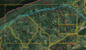
The picture to the right is Virginia as made up of permalinks within a spreadsheet. Each editor participating in Virginia 2025 should select one area at a time. Zoom=2 was selected to give a decent amount of area to work but not be so overwhelming that you will never complete the area. Since permalinks are different sizes based on an editor's computer settings. The magnification of the screen plays into account so selecting two adjacent PLs may leave a gap in coverage on your screen while there is overlap on another editors' screen.
Note some areas have overlap with neighboring states, some areas have only water, and some areas have very few roads. So like these are like Forrest Gump's box of chocolates, "You never know what you're gonna get" until you jump in and look at it.
Select ONE area that you want to work on on the first tab PL.
Preferentially pick an area that is already within your editing area. (Driving/AM/LAM)
Copy the permalink and look at it on your computer.
If you like the area selected above:
Change the background color to yellow for your chosen area on the first tab "PL Map".
Change to the spreadsheet's second tab, "Editor", and overwrite the PL with your editor name; also change the color to yellow.
Commence editing in the area, if you already have editing rights.
If all areas in your editing area are done, then you may submit for an Area Manager expansion by using the Area Manager application to the MAR Regional Coordinator.
Note the submission for AM will go through the normal AM request process for review and needs to meet the normal AM request requirements.
The AM will be a permanent AM assignment, it is not a temporary Virginia 2025 area; this is not a map raid for two weeks.
Edit the area
Divide the road from a two way segment to separate one way segments per the current guidance if there is a cement median or painted area prohibiting traffic
Add Junction box to prohibit any u-turn that is prohibited on a H or # intersection
Add a Junction box if it provides better timing data collection for the left/straight junctions
Until u-turn prevention is removed, add a Junction box for any median segment that has an allowable u-turn when the median segment is <16m
Add Lane guidance on all applicable road segments
Enter/verify correct road names, including proper abbreviations used
Enter proper city name(s)
Primary city name is:
City/village/town if with incorporated boundary
Census Designated Place
None if not either of the above options
Alternate city name is:
The USPS city name if different than the primary city listed above
A second city name if road segment is on the boder between areas that meet the first two primary cities above
Edit the segment for correct direction(s) of travel
Edit the segment for proper turn restrictions, including time based turn restictions
Edit the segment for proper time based segment restrictions if applicable
Verify the segment's road type compared to the VDOT functional classification
Add/edit the segment for house numbers
Use WME house numbers if at all possible
Use a residential place point if
A WME house number does not provide proper routing to a place that is not on the named road segment
Another house exists within Virginia's borders with the same house number, road name, AND the primary city is None; you will receive an error message that the HN already exisits and you cannot force the Save.
Please add all known addresses as a house number (or if needed a residential point place) since Waze interpolation is very low in priority and can be overridden by other sources during search. We are trying to make our work be lasting. So as long as the building is standing, it doesn't matter if the business changes names; the address that you enter will still work.
Finished the area
Change your area's background color to GREEN for your chosen area on the first tab "PL Map".
Change to the spreadsheet's second tab, "Editor Assignment"; leave your editor name there and change the background color to GREEN.
A good way to see if you have done all of the area is to use JustinS83's Been There script. Make a box around the PL at zoom=2 and then zoom into one corner and mark it with a box, survey/scan to make sure all segments are complete. Move to the edge of the smaller box and then mark the new section and survey/scan; repeat as necessary. Once all the larger box is filled in with the smaller boxes. then your area is complete.
Had fun and want some more? Then go ahead and grab your next one!
Communication
Discord is the primary means to communicate during this effort. You must be in the MAR Discord server to participate in Virginia 2025.
Therefore, if not already on the MAR Discord server, then please request to join by using this link.
But since some don't have 24/7 access to Discord you CAN edit while not able to be on Discord temporarily. Please set yourself visible and enable the Live Users layer when editing in Virigina. That way people can see you via Live Users and reach out via WME Chat if required; additionally ask to be added to the Virginia Google Hangout channel, if GHO is available to you, since it is synched to Discord.
Virginia 2025 is not a map raid; therefore it will not have specific group leaders. Please ask your questions or post up/downlock requests in the Virginia Discord channel/GHO.
If you do not understand anything, please askǃ If you need help figuring out where to start, please askǃ If you think you did something correctly, but aren't sure, please askǃ The MAR community is more than happy to help resolve your question/concern and more than likely there is someone else who is pondering the same item.
Editor restrictions
R1/R2 editor restrictions
Welcome R1 and R2 editors and thanks for your participation in the Virginia 2025. We know how frustrating it can be to not be able to delete (or do many name changes on) segments that you did not create. We feel your pain, but this is a long term project so relax, you can get to it tomorrow. If you absolutely positively need us to address it now, just ask in Discord and we'll be more than happy to help with deletions or renamings.
Complete each segment before moving on. When you find a point on the map to do an edit, please take the time to finish all the associated items with that edit before moving on. The basemap wiki is an excellent checklist for editing roads even if you are working on a road that is not basemap.
Local Guidance
VA Roads/Routes
Road names in Virginia use the noun name as the primary segment name with the route number as an alternate. If addresses are using the route number AND there is signage for the route number but not the noun name then the route number can be the primary name. Follow the nationwide Road Name guidance. Pay specific attention to the list of approved Abbreviations and acronyms, and when in doubt: "spell it out". If you have any other questions or concerns please contact a MAR Large Area Manager or a MAR State Manager.
The city name for the primary name is either the incorporated city/town/village name, CDP name, or None.
If the segment falls within an incorporated city/town/village or CDP, then all alternate segment names should also include the same primary city name for the city/town/village/CDP.
If the segment falls outside of a city/town/village/CDP, then the primary city name should be left blank and the "None" check box selected. The segment's primary road name should be duplicated in the alternates and all alternate names should use the USPS Zip Code City name. Do not check "None" for any of the alternate city names. If there is more than one listed USPS Zip Code City for a given ZIP, use the city name used for that address. Using another "default" name will mean the Waze house number or residential place point is not used.
If the segment runs along the border between two cities or CDPs, then the primary city name should be left blank and the "None" check box selected. The primary segment name should be duplicated in the alternates for both city/CDP names as well as the alternate segment names. Do not check "None" for any of the alternate city names. This guidance should also be applied when the segment falls outside of a city/CDP but borders two USPS Zip Code City.
Alleys
Alleys in Virginia follow the policy above and are Private road. Do NOT use the new road type "Narrow Street/Alley" in Virginia.
Functional Classification
Information on functional classification in Virginia can be found here. For editors rank 3 and above see the functional classification script in the Virginia Wazeopedia page.
MAR Minimum Road Lock Standard
Minimum Road Lock Standard
Segment Type
Direction
Lock
Freeway
5
Ramp
4
Major Highway
4
Minor Highway
3
Primary Street
One-way Two-Way
3 2
Street Private Road
One-way Two-Way
2 1
|-|-|-|-|-|-|-|-|-| Railroad |-|-|-|-|-|-|-|-|-|
2
• • • • Ferry • • • •
5
⁃ ⁃ ⁃ ⁃ ⁃ Runway ⁃ ⁃ ⁃ ⁃ ⁃
4
Other Named Types
5
Note that these are minimums and, for protection, certain segments may be at higher lock levels. If you find a road locked to a higher level than its minimum, please ask for clarification.
Virginia Update Request Management
This will not be a "primary focus" of the Virginia 2025, but please feel free to work any UR/PUR/MP's in your editable area. If you receive an AM assignment then the UR/PUR/MP's are definitely within that role, so jump in. Remember to follow the Virginia Response Timeline.
Cameras
Very few cameras will not be mapped
Most places in Virginia do not allow red light cameras. Special permission has to be obtained to have them. You may see some fake cameras on the map. Cameras that were in place have been left as a visual deterrent; therefore they are marked as fake. Virginia allows speed cameras in school and work zones.
To prevent loss of data due to automatic acceptance of submissions from "trusted users", all area places and points with complete data should be locked to Level 2 at a minimum.
Additionally, please consult the following table for minimum lock level for completed places.
Place Type
Minimum Lock Level
Area/Point Places
2
Gas Stations
3
Hospital/Medical Care
4
Fire Department
4
Police Station
4
Airports
4
Parking Lot Area (PLA)
3
Reference Links
Virginia Wazeopedia Page
If you have any questions regarding VA standards during editing and you cannot find the answer on this page, please visit the Virginia Wazeopedia Page and/or the MAR Wiki Page.
Recommended Tools for Virginia 2025
There are many scripts and extensions that editors use to assist with editing that not only make some jobs easier, but verifies what we do is correct. The use of these scripts is highly encouraged and those listed below are the ones you should install, at a minimum, to get started.
Once you have installed Toolbox, press the Toolbox Icon and select a minimum of the following options:
TamperMonkey
You will need to install a browser extension to manage the additional scripts. Some scripts do not work with the current version of GreaseMonkey, so we recommend installation of TamperMonkey.
WME GIS Layers adds GIS layers to WME for states and counties that provide a public ESRI/ArcGIS interface. Typically, these layers include tax parcels (often with address labels) and/or address points.
WME Validator Validates a map area, highlights issues and provides a detailed report with Wazeopedia references and How-tos.
WME Validator Virginia Localization this is an add-on script to Validator highlighting issues specific for Virginia with a Wazeopedia Reference.
WME US Government Boundaries layer will display the ESTIMATED USPS city name for the CENTER of the displayed screen. At the boundaries it can be inaccurate. Some areas shifting a few pixels can change the city name between four different cities (or a few states). So remember it is a tool and can be checked with individual addresses by checking the zip code for an address.
If you prefer, the CDP outlines can be loaded into WME using the WME Geometries script.
Quick HN Allows you to set starting HN and then go up by +1 (T), +2 (R), or user selected increment (E)
WME Junction Angle Info helps with junction maintenance. If two connected segments are selected, it shows the turn angle, and estimates navigation instructions. Otherwise it shows the the angle between each segment.
WME Simple Permalink shortens WME permalinks by removing any layer and filter specifications.
WME FS MVUM GIS Map opens a Forest Service Motor Vehicle Use Map in another window, at the same location as the WME map. Keeps the location of the GIS map synced to WME.
Area Managers
The table below identifies the editors also designated as Area Managers or higher who are editing in Virginia. If you have any questions, please consider contacting them directly as needed. If you are an Area Manager that covers Virginia, or a USA Country Manager that does a lot of work in Virginia, please add yourself to this list (alphabetical by username) in the correct rank section.
The editor who also serves as the Regional Coordinator for Virginia is automatically listed at the top of the table. That editor may not be highly active in this state and therefore may not be listed separately in the table.
Interested in becoming a Virginia Area Manager or think you qualify for a promotion? Talk to a State Manager or Regional Coordinator and fill out an area manager application.
New role - Mid-Atlantic Region Large Area Manager (MAR-LAM!
Please read the information about MAR-LAM on the MAR wiki. If interested in becoming a Virginia MAR-LAM, then please contact one of the Virginia State Managers.
Virginia — Area, State, Country Managers, and Regional Coordinators
The following editors are also editing in the state and may be working towards an Area Manager position. Feel free to contact them for assistance in their respective areas.