(*/Major_roads/Main*/ Locking standard template) |
Poncewattle (talk | contribs) m (Fixed broken link for route index link) |
||
| Line 5: | Line 5: | ||
In Virginia, outside cities and major towns (and a couple of urban counties), nearly every road and street is designated as a "state highway" and assigned a number for VDOT inventory purposes. However, for Waze routing, we only treat '''primary''' state highways as "numbered state highways" for purposes of applying the [[Road types/USA|road type guidelines]]. Highways marked with '''primary''' route numbers must be designated as at least "Minor Highway" in Waze, unless the road's functional classification requires a higher designation. For Virginia secondary highways, rely on the road's functional classification only. | In Virginia, outside cities and major towns (and a couple of urban counties), nearly every road and street is designated as a "state highway" and assigned a number for VDOT inventory purposes. However, for Waze routing, we only treat '''primary''' state highways as "numbered state highways" for purposes of applying the [[Road types/USA|road type guidelines]]. Highways marked with '''primary''' route numbers must be designated as at least "Minor Highway" in Waze, unless the road's functional classification requires a higher designation. For Virginia secondary highways, rely on the road's functional classification only. | ||
Primary state highways have numbers in the range of 2 to 599 (and, as an exception, 895), displayed in a route marker using a shield design. All other numbers from 600 up are secondary highways; if these roads have route markers (many do not), they use a circle design instead of a shield. See [http://www.virginiadot.org/info/resources/route-index-07012003.pdf | Primary state highways have numbers in the range of 2 to 599 (and, as an exception, 895), displayed in a route marker using a shield design. All other numbers from 600 up are secondary highways; if these roads have route markers (many do not), they use a circle design instead of a shield. See [http://www.virginiadot.org/info/resources/route-index-07012003.pdf Virginia DOT Route Index Resources] for more info. | ||
<gallery> | <gallery> | ||
File:Virginia 28.png|Primary route marker | File:Virginia 28.png|Primary route marker | ||
Revision as of 19:05, 17 January 2015
- For further information, see Road names/USA, Road types/USA and Virginia/Mapping resources.
In Virginia, outside cities and major towns (and a couple of urban counties), nearly every road and street is designated as a "state highway" and assigned a number for VDOT inventory purposes. However, for Waze routing, we only treat primary state highways as "numbered state highways" for purposes of applying the road type guidelines. Highways marked with primary route numbers must be designated as at least "Minor Highway" in Waze, unless the road's functional classification requires a higher designation. For Virginia secondary highways, rely on the road's functional classification only.
Primary state highways have numbers in the range of 2 to 599 (and, as an exception, 895), displayed in a route marker using a shield design. All other numbers from 600 up are secondary highways; if these roads have route markers (many do not), they use a circle design instead of a shield. See Virginia DOT Route Index Resources for more info.
-
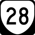
Primary route marker
-

Secondary route marker


Locking standard
Actual locks used may be more or less than values in the table below, depending on area circumstance
Please consult the RC, SM, or appropriate AM for guidance
| Segment Type | Urban | Rural | |||||||||
|---|---|---|---|---|---|---|---|---|---|---|---|
| Freeway | 5 | ||||||||||
| Ramp | Highest rank of connected segment | ||||||||||
| Major Highway | 4 | 3 | |||||||||
| Minor Highway | 3 | 2 | |||||||||
| Primary Street | 2 | 1 | |||||||||
| Street | 1 | ||||||||||
| • • • • Ferry • • • • | 5 | ||||||||||
| |-|-|-|-|-|-|-|-|-| Railroad |-|-|-|-|-|-|-|-|-| | 2 | ||||||||||