(Copied from https://wiki.waze.com/wiki/index.php?title=User:Voludu2/Mapraid/Blank&oldid=107595) |
|||
| (93 intermediate revisions by 4 users not shown) | |||
| Line 1: | Line 1: | ||
{{mbox | {{mbox|text=This map raid is over! Thank you for your help. Check back here for results.}}<!-- | ||
remove everything up to and including the next ">" to remove that "under construction" message. | remove everything up to and including the next ">" to remove that "under construction" message. --><!-- | ||
--> | |||
<!-- | |||
If they want a postcard/meme, put it up at the front. | |||
[[File:Mapraid JerseyShore meme3.jpg|frameless|550px|center]] | |||
--><!-- | |||
<div style="width:550px;height:200px; margin-left:auto; margin-right:auto;border: 1px solid black;">Do you want a picture here?</div> | |||
--> | |||
'''MapRaid Philadelphia June 2015''' | |||
will be '''7 June at 17:00 UTC (1:00 PM EDT) through 14 June 2015'''. | |||
The group will be divided into | |||
5 | |||
groups, one for each section. Each group will have both local and senior editors, one of which will be the "Group leader" - listed in blue below. Please direct all questions to your group leaders. The raid hosts will be available across all areas for added support. | |||
==Mapraid Host== | |||
{| class="wikitable" | |||
|- | |||
! Editor !! Location !! Roles | |||
{{AM/Editor|orbitc|6|Regional Coordinator|Map Raid Organizer|badge1=rc|badge2=gc}} | |||
|} | |||
== | == MapRaid Goals == | ||
Our primary goal is '''Improve Basemap''' | |||
<!-- | <!-- <div style="column-count:2;-moz-column-count:2;-webkit-column-count:2"> --> | ||
Secondary Goals | |||
* Improve Routing and Navigation. | |||
* Solve / Respond to User Reports. | |||
* PURs (Places) | |||
* MPs | |||
* General map verification, restricted turn verification (Shift + Z) | |||
* Functional Classification. | |||
== Groups == | |||
<!-- | |||
Here's how to make an imagemap: | |||
http://i.imgur.com/Ta6Rzft.png?1 | |||
Upload the image to the wiki. | |||
Right click on "original image" and copy image URL | |||
Go to .... | |||
in .... web, past the image URL and hit the accept on that line | |||
select "wiki imagmap" | |||
start drawing | |||
when you are done, copy everything out of the box into a simple editor like notepad | |||
starting at the first rectangle or polygon | |||
replace all [[ with [ | |||
replace all |]] with ] | |||
replace all | with " " | |||
replace all ]] with ] | |||
Correct the image. | |||
Use parameters you would use with any image link. Use thumb or frameless if you want to control size | |||
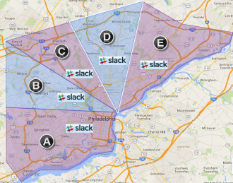
--><imagemap>Image:MR_PA.png|thumb|330px|alt=Map of Philadelphia Area with Mapraid Pennsylvania areas shown|Click on your map raid group to edit in your area or "#Slack" logo to go to your slack channel. | |||
rect 219 412 310 441 [https://wazemapraid.slack.com/messages/mr_pennsylvania_a/ Mapraid Slack Channel A] | |||
rect 191 310 284 341 [https://wazemapraid.slack.com/messages/mr_pennsylvania_b/ Mapraid Slack Channel B] | |||
rect 218 232 310 260 [https://wazemapraid.slack.com/messages/mr_pennsylvania_c/ Mapraid Slack Channel C] | |||
rect 328 186 419 216 [https://wazemapraid.slack.com/messages/mr_pennsylvania_d/ Mapraid Slack Channel D] | |||
rect 467 201 557 231 [https://wazemapraid.slack.com/messages/mr_pennsylvania_e/ Mapraid Slack Channel E] | |||
poly 22 358 388 376 373 415 210 409 211 447 381 445 377 506 305 521 223 572 128 567 71 605 17 540 [https://www.waze.com/editor/?env=usa&lon=-75.30024&lat=39.91134&zoom=1 Mapraid Area Group A] | |||
poly 19 137 288 306 184 306 189 345 291 344 292 356 21 355 [https://www.waze.com/editor/?env=usa&lon=-75.285751&lat=40.006251&zoom=1 Mapraid Area Group B] | |||
poly 23 136 244 71 315 232 214 230 216 259 [https://www.waze.com/editor/?env=usa&lon=-75.238536&lat=40.048405&zoom=1 Mapraid Area Group C] | |||
poly 315 235 389 371 228 264 317 266 [https://www.waze.com/editor/?env=usa&lon=-75.238536&lat=40.048405&zoom=1 Mapraid Area Group C] | |||
poly 250 69 480 4 436 188 323 183 329 224 421 225 392 371 [https://www.waze.com/editor/?env=usa&lon=-75.126822&lat=40.095077&zoom=1 Mapraid Area Group D] | |||
poly 481 11 607 80 766 106 767 155 587 232 563 230 562 193 464 196 464 237 574 242 396 374 [https://www.waze.com/editor/?env=usa&lon=-75.005186&lat=40.071767&zoom=1 Mapraid Area Group E] | |||
#<!-- Created by Online Image Map Editor (http://www.maschek.hu/imagemap/index) --> | |||
</imagemap> | |||
<!-- | |||
=== | The team list goes here. something like--><div style="width: 340px"> | ||
{{#widget:Iframe | |||
|url=https://docs.google.com/spreadsheets/d/1R1Z_UjXVKjUhraEw8wMCxRQvH_rDBpt0fTGn30FJt6Y/pubhtml?gid=1571469040&single=true | |||
|width=350 | |||
|border=0 | |||
|height=2100}} | |||
<!-- | |||
<div style="width:350px;height:1500px; border: solid black 2px;">Placeholder for group list</div>--> | |||
<br style="clear: all;" /></div> | |||
__TOC__ | |||
==About this map raid== | |||
<!-- add any important information important to the raid here --> | |||
<!-- keep this list short. link to other pages where possible.--> | |||
Please read the entire MapRaid wiki. If you are still uncertain what to do about something you see on the map, please ask your group leader. | |||
Beginning and junior editors -- find a senior editor and start asking questions. Take this raid as a learning opportunity. Everything new you learn -- do a little follow-up reading in the wiki to make sure you understand. The more you learn, and the more positive interaction you get with the senior editors, the better you can prepare yourself for a future rank upgrade or area expansion. There are always a few promotion announcements at the end of every map raid. | |||
'''Thank You for your help with the map.''' | |||
== | ===Mapraid UR Rules=== | ||
We will follow the [[Update_Requests_in_Waze_Map_Editor#The_resolution_process_.2F_Etiquette|usual US UR etiquette]] with one exception: | |||
During the Map raid, the wait time is reduced to | |||
4 | |||
days. | |||
Do not close URs if the UR contains a tag such as [NOTE], [CLOSURE], or any other [MESSAGE] -- check with the editor who placed the tag. | |||
=== | === Do Not Mass-Edit === | ||
DO NOT perform edits that affect large numbers of segments at once. We want to be able to see how URs and other problems got resolved. Mass edits can be done at the end of the map raid. | |||
[[File:Jct 4 offset align.png|frameless|right|100px]] | |||
=== Micro-Doglegs === | |||
We use [[Glossary#Micro-dogleg|micro-doglegs]] to control turn- vs. stay/keep/exit instructions. Zoom in very close to see the closely-spaced geometry nodes. Preserve them. | |||
=== Road Types, Names, and Functional Classification (FC) === | |||
In | |||
Pennsylvania | |||
, we follow general [[Road types#Quick_reference_chart|US standards for road types]] based on the hybrid rule of FC and Route Type. | |||
Special road names are | |||
* Federal: '''I-195 E''', '''US-9''' | * Federal: '''I-195 E''', '''US-9''' | ||
* State: '''SR-35 S''', '''SR-72''' | * State: '''SR-35 S''', '''SR-72''' | ||
* | ** If the state road appears on the sign that drivers see as PA-xxx, use that in the road name. <!--* Most signs for the Pennsylvania Turnpike refer to it as "Penna Turn Pike".--> | ||
If a road has more than one name follow the standard for [[Road names#Concurrent_names|Concurrent names on US roads]]. | |||
===Road Locks=== | |||
{{Lock Standard State|PA}} | |||
=== | ===Places=== | ||
Pennsylvania generally follows the US standards for [[Places]], but there are some exceptions. | |||
Please see the [//w-tools.org/ValidationInfo?rules=Pennsylvania the Pennsylvania Places Validation Rules] in the [//w-tools.org/PlaceBrowser?group=MapRaidPhilly Map Raid Place Browser] for more details. | |||
Trust the rules in the places browser. | |||
<!-- | |||
===City Names=== | |||
City names are not required on Freeways and Ramps. Every other segment should have a city name. Use the city, borough, or township name, or else the Census Designated Place name. Do not use postal names or areas. | |||
For more information, please see [[Pennsylvania#Cities_and_towns|Pennsylvania Cities and towns]] | |||
<!-- | --> | ||
<!-- ===Left Turns=== | |||
? | |||
;Left turns are prohibited when: | |||
:* a posted sign prohibits the left turn | |||
:* there are two double yellow lines Sometimes, there is a raised median or diagonal striping between.This is often seen in the form of the "bubble" prior to a dedicated left turn lane, | |||
:* there is a dedicated left turn lane in the main road, not counting a bi-directional "suicide" center turn lane. | |||
;Left turns are allowed when: | |||
:* They are not prohibited (see above) | |||
:* Left turns are even allowed across a double-yellow line into a driveway or private road or parking lot. Double-yellow lines are usually interrupted at a public street where a left turn is permitted. | |||
--> | |||
===How to order a Philly cheesesteak=== | |||
If you go to Pat's or Geno's, don't ask for a cheese steak -- that's redundant. Say "One, provolone, with". Or, if you must, "One, wiz, with". | |||
== Communication == | == Communication == | ||
We will use ''#''Slack Channels. There is a [//wazemapraid.slack.com/messages/mr_pennsylvania/ Pennsylvania Raid general channel] and also a channel for each raid group. {{U|Please be sure to join the slack WazeMapRaid Team and join the channels for the specific MapRaid and group you are assigned to.}} If you are not already part of the WazeMapRaid slack team, '''Click here to get your [http://bit.ly/GetWazeSlackInvite Slack invitation]. Be sure to choose {{u|WazeMapRaid}} to the MapRaid question.''' If you have trouble getting into the slack team and channels, please reach out to one of the MapRaid organizers. | |||
WME chat can also be used. The [http://www.waze.com/forum/viewtopic.php?f=819&t=95038 WME Chat addon] is recommended. | WME chat can also be used. The [http://www.waze.com/forum/viewtopic.php?f=819&t=95038 WME Chat addon] is recommended. | ||
| Line 101: | Line 172: | ||
=== Recommended Tools for MapRaid === | === Recommended Tools for MapRaid === | ||
* | * [//greasyfork.org/en/scripts/10229-wme-philly-mapraid-overlay Mapraid Overlay] tampermonkey/greasemonkey required | ||
* | * [//w-tools.org/PlaceBrowser?group=MapRaidPhilly Map Raid Place Browser] | ||
* [//wiki.waze.com/wiki/User:Rickzabel/UrComments/ UR Comments] - a tremendous time and labor saving tool with automation and integration with URO+, to help with working URs. Read the documentation. | * [//wiki.waze.com/wiki/User:Rickzabel/UrComments/ UR Comments] - a tremendous time and labor saving tool with automation and integration with URO+, to help with working URs. Read the documentation. Tampermonkey / greasemonkey required | ||
* The [http://drive.google.com/file/d/0B8WbeRGWGEOjQ1BvbHFtYlJSV2pIOVdyQlgtRmJzQUtHNjRz WME Reference Sheet<sup><small><nowiki>[PDF]</nowiki></small></sup>] is a printable double-sided tri-fold quick reference guide to some of the common topics used in WME. | * The [http://drive.google.com/file/d/0B8WbeRGWGEOjQ1BvbHFtYlJSV2pIOVdyQlgtRmJzQUtHNjRz WME Reference Sheet<sup><small><nowiki>[PDF]</nowiki></small></sup>] is a printable double-sided tri-fold quick reference guide to some of the common topics used in WME. | ||
* [http://www.waze.com/forum/viewtopic.php?t=76488 Validator] is a script that validates a map area in Waze Map Editor, highlights issues and generates a very detailed report with wiki references and solutions. | * [http://www.waze.com/forum/viewtopic.php?t=76488 Validator] is a script that validates a map area in Waze Map Editor, highlights issues and generates a very detailed report with wiki references and solutions. | ||
** Chrome browser: please download the script at [http://chrome.google.com/webstore/detail/wme-validator/baojhpeknpmkhplkcnpdcficcaaniaih Chrome Web Store] | ** Chrome browser: please download the script at [http://chrome.google.com/webstore/detail/wme-validator/baojhpeknpmkhplkcnpdcficcaaniaih Chrome Web Store] | ||
** Firefox browser: please download the script at [http://greasyfork.org/scripts/1571-wme-validator GreasyFork.org] -- | ** Firefox browser: please download the script at [http://greasyfork.org/scripts/1571-wme-validator GreasyFork.org] -- tampermonkey or greasemonkey required | ||
* [http://greasyfork.org/en/scripts/2103-wme-chat-addon WME Chat Addon] is a script that improves the WME chat GUI. For a list of all the features check the thread [http://www.waze.com/forum/viewtopic.php?f=819&t=95038 here] -- Tapermonkey/Greasmonkey required | * [http://greasyfork.org/en/scripts/2103-wme-chat-addon WME Chat Addon] is a script that improves the WME chat GUI. For a list of all the features check the thread [http://www.waze.com/forum/viewtopic.php?f=819&t=95038 here] -- Tapermonkey/Greasmonkey required | ||
===Mapping Resources=== | |||
:[http://maps.psiee.psu.edu/paatlas/ PASDA Pennsylvania online Atlas] | |||
For more information, please see [[Pennsylvania/Resources]] | |||
* City/County of Philadelphia (all groups) [http://www.phila.gov/map Street], [http://citymaps.phila.gov/portal/ address] and [//www.dot7.state.pa.us/BPR_PDF_FILES/MAPS/Traffic/Functional_Class/Giscty67.pdf FC] | |||
* Delaware County (groups A, B, C) [http://w01.co.delaware.pa.us/pa/publicaccess.asp?municipality=03&realdistaddress=Submit&HNumber=&Street=a&Folio=&Map=&UAYN=Y Parcels] and [http://www.dot7.state.pa.us/BPR_PDF_FILES/MAPS/Traffic/Functional_Class/Giscty23.pdf FC] | |||
* Montgomery County (groups B, C, D) [http://www.montcopa.org/DocumentCenter/View/2167 Streets (PDF)], [http://www.montcopa.org/DocumentCenter/View/2169 County Roads] and [http://www.dot7.state.pa.us/BPR_PDF_FILES/MAPS/Traffic/Functional_Class/Giscty46.pdf FC] | |||
* Bucks County(E and D) [http://www.buckscountyboa.org/pt/search/commonsearch.aspx?mode=address Parcels] and [http://www.dot7.state.pa.us/BPR_PDF_FILES/MAPS/Traffic/Functional_Class/Giscty09.pdf FC] | |||
* Chester County (group 2 -- a tiny corner) [http://mapservices.chesco.org/chescoviews/Splash.aspx Streets and Parcels] and [http://www.dot7.state.pa.us/BPR_PDF_FILES/MAPS/Traffic/Functional_Class/Giscty15.pdf FC] | |||
== Mapraid edit lists == | == Mapraid edit lists == | ||
| Line 116: | Line 197: | ||
== Results == | == Results == | ||
Great job for the first ever PA MR. Incredible improvements on the connectivity score. | |||
[[File:HOF Philadelphia.png|frameless|700px]] | |||
| | |||
| | |||
== MapRaid Promotions == | == MapRaid Promotions == | ||
| Line 131: | Line 211: | ||
| text = Watch here for results of promotions during and after the raid. | | text = Watch here for results of promotions during and after the raid. | ||
}} | }} | ||
[[Category:Mapraid]] | [[Category:Mapraid]] | ||
Latest revision as of 22:26, 6 September 2017
| This map raid is over! Thank you for your help. Check back here for results. |
MapRaid Philadelphia June 2015 will be 7 June at 17:00 UTC (1:00 PM EDT) through 14 June 2015. The group will be divided into 5 groups, one for each section. Each group will have both local and senior editors, one of which will be the "Group leader" - listed in blue below. Please direct all questions to your group leaders. The raid hosts will be available across all areas for added support.
MapRaid Goals
Our primary goal is Improve Basemap
Secondary Goals
- Improve Routing and Navigation.
- Solve / Respond to User Reports.
- PURs (Places)
- MPs
- General map verification, restricted turn verification (Shift + Z)
- Functional Classification.
Groups
About this map raid
Please read the entire MapRaid wiki. If you are still uncertain what to do about something you see on the map, please ask your group leader.
Beginning and junior editors -- find a senior editor and start asking questions. Take this raid as a learning opportunity. Everything new you learn -- do a little follow-up reading in the wiki to make sure you understand. The more you learn, and the more positive interaction you get with the senior editors, the better you can prepare yourself for a future rank upgrade or area expansion. There are always a few promotion announcements at the end of every map raid.
Thank You for your help with the map.
Mapraid UR Rules
We will follow the usual US UR etiquette with one exception: During the Map raid, the wait time is reduced to 4 days. Do not close URs if the UR contains a tag such as [NOTE], [CLOSURE], or any other [MESSAGE] -- check with the editor who placed the tag.
Do Not Mass-Edit
DO NOT perform edits that affect large numbers of segments at once. We want to be able to see how URs and other problems got resolved. Mass edits can be done at the end of the map raid.

Micro-Doglegs
We use micro-doglegs to control turn- vs. stay/keep/exit instructions. Zoom in very close to see the closely-spaced geometry nodes. Preserve them.
Road Types, Names, and Functional Classification (FC)
In Pennsylvania , we follow general US standards for road types based on the hybrid rule of FC and Route Type. Special road names are
- Federal: I-195 E, US-9
- State: SR-35 S, SR-72
- If the state road appears on the sign that drivers see as PA-xxx, use that in the road name.
If a road has more than one name follow the standard for Concurrent names on US roads.
Road Locks
In Pennsylvania we have a set minimum standard for locking roads based on segment type. Any road of a certain segment type must be locked at least to the rank (level) in the chart below. Roads may be locked higher for protection and special situations (areas with construction, tricky design, frequent mistakes, imaging inaccuracies, and the like), but should not be locked lower.
A great time to implement these locks is while bringing the road types of an area into compliance with the current US road type standards (FC and highway systems). Lock the roads based on type after they've been set to current US road type standards.
| Segment Type | Statewide |
|---|---|
| Freeway | 5 |
| Ramp | Highest rank of connected segments |
| Major Highway | 3 |
| Minor Highway | 3 |
| Primary Street | 2 |
| Street | 1 (Auto) |
| Private Road | 1 (Auto) |
| • • • • Ferry • • • • | 5 |
| |-|-|-|-|-|-|-|-|-| Railroad |-|-|-|-|-|-|-|-|-| | 2 |
Note: Do Not Mass Edit just to update locks to these standards, these can be adjusted as you find them while editing other aspects of the segments such as FC, speed limits, naming, etc.
Some segments still warrant higher locks and care should be taken when setting segment lock to these standards to look for and protect these special setups with higher locks. Some examples; segments which are part of BDP, U-turn prevention, or using micro-doglegs, or other complex intersection setups.
Places
Pennsylvania generally follows the US standards for Places, but there are some exceptions. Please see the the Pennsylvania Places Validation Rules in the Map Raid Place Browser for more details.
Trust the rules in the places browser.
How to order a Philly cheesesteak
If you go to Pat's or Geno's, don't ask for a cheese steak -- that's redundant. Say "One, provolone, with". Or, if you must, "One, wiz, with".
Communication
We will use #Slack Channels. There is a Pennsylvania Raid general channel and also a channel for each raid group. Please be sure to join the slack WazeMapRaid Team and join the channels for the specific MapRaid and group you are assigned to. If you are not already part of the WazeMapRaid slack team, Click here to get your Slack invitation. Be sure to choose WazeMapRaid to the MapRaid question. If you have trouble getting into the slack team and channels, please reach out to one of the MapRaid organizers.
WME chat can also be used. The WME Chat addon is recommended.
Reference Links
The Basics
- New editor welcome page
- Waze Map Editor
- Best Map Editing Practice
- Editing manual
- Common editing mistakes
- How to make a Permalink
- All about using the WME Chat
- Community Plugins, Extensions and Tools where you'll links and descriptions to most of the editing scripts being used. Some of these are essential to good editing, and others make the editing process much easier. WME Validator, URO+, and WME Toolbox are highly recommended.
Recommended Tools for MapRaid
- Mapraid Overlay tampermonkey/greasemonkey required
- Map Raid Place Browser
- UR Comments - a tremendous time and labor saving tool with automation and integration with URO+, to help with working URs. Read the documentation. Tampermonkey / greasemonkey required
- The WME Reference Sheet[PDF] is a printable double-sided tri-fold quick reference guide to some of the common topics used in WME.
- Validator is a script that validates a map area in Waze Map Editor, highlights issues and generates a very detailed report with wiki references and solutions.
- Chrome browser: please download the script at Chrome Web Store
- Firefox browser: please download the script at GreasyFork.org -- tampermonkey or greasemonkey required
- WME Chat Addon is a script that improves the WME chat GUI. For a list of all the features check the thread here -- Tapermonkey/Greasmonkey required
Mapping Resources
For more information, please see Pennsylvania/Resources
- City/County of Philadelphia (all groups) Street, address and FC
- Delaware County (groups A, B, C) Parcels and FC
- Montgomery County (groups B, C, D) Streets (PDF), County Roads and FC
- Bucks County(E and D) Parcels and FC
- Chester County (group 2 -- a tiny corner) Streets and Parcels and FC
Mapraid edit lists
Spreadsheets and forms are being used to streamline management of various group efforts and track important edits. Below you can find links to use these these forms, sheets, and see the lists.
Results
Great job for the first ever PA MR. Incredible improvements on the connectivity score.

MapRaid Promotions
Some editors really let their bright side out, and let their community skills shine. This is even more evident in a concerted group effort with high-density editing like a MapRaid!. Editors of all ranks working closely with each other and the Champs, really lets us everyone get to know each other, and allows certain editors to be recognized for their skills and effort.
When the Champs see someone consistently editing well, interacting well with the community, and knowledgeable of the various details from the Wiki, they can issue promotions. This can be anything from the size of a managed area, to a rank increase, or even a new role.
| Watch here for results of promotions during and after the raid. |