This page serves as the primary resource for editors of Pennsylvania. Review all the sections to better understand how the guidelines for this state might deviate from the overall USA or worldwide guidelines. If you have any comments or questions about this page or state refer to the community links below.
Get WME City Merge Place Address Fixer. Enable this Tampermonkey script and click on a place that looks like it has no address. If the script can get that street and city name from the smae place the app gets it from, it will. Otherwise, it will let you know. Either way, double check before you save. For more information, please see Addresses damaged by City Merge
Mapping resources
Before editing the maps in Pennsylvania, be sure to fully review and understand the editing manual.
The Waze user community follows the Waze etiquette guidelines discussed in the Wiki. Be sure to familiarize yourself with these guiding principals while editing the maps and this Wiki, as well as when communicating with other Waze users.
Tip:Editors are strongly encouraged to download & install the WME Toolbox & Waze Validator Plugins. These are VERY helpful tools for identifying problems and even offers advice how to fix them.
Community
The Waze forum is a great place to find answers to previously asked questions and also a place to ask new ones. Below are links to the forums specific to Pennsylvania.
New editors should consider checking into the formal mentoring program available at no charge.
Many Pennsylvania editors use Discord to share information and chat. If you are editing or plan to edit in PA, please join the Northeast Discord Server listed below.
One of the most common errors when editing the maps is when an editor creates a road and does not confirm the road by setting the city and road name (or stating it has none).
to find a destination when you enter an address into the waze app.
Every segment in Pennsylvania is located within a city, borough, or township, so every segment of every Minor Highway, Primary Street, Street, Private Road, Parking Lot Road, and Dirt Road/4x4 Trail should have a city name applied to it. Major Highways should have a city name applied to all segments that also have street addresses. City names are not required on Freeways and Ramps. Railroads should have the "none" box checked for city.
If you think you have found a place that needs an exception to the rules below, please contact a Pennsylvania state manager.
City, borough, or township?
If the segment is within a city or borough, use the name of the city or borough
If the segment is not within a city or borough, but within a Census Designated Place (CDP) that is used as though it were a town name by the businesses and residents then use the CDP name. This means that the CDP name does not appear only in mailing addresses (many CDP names are identical to post office names), but is used in the names of businesses, schools, religious centers, as in "Exton Square Mall"
If the segment does not satisfy the rules above, then use the township name.
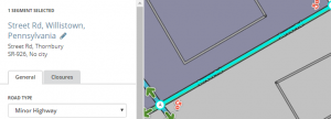
If the segment runs along the border of two different city names, then use one in the primary city name and one as the alternate. Example: Street Rd, Willistown, with alternate name Street Rd, Thornbury.
Where a segment crosses a city boundary, make sure there is a junction at the border, and that each segment gets the correct city name or names.
Do NOT use Post Office names that don't match an official township, boro, or CDP in the segment primary address. Do not use names of villages, neighborhoods, or other unincorporated places in the primary address.
If the above rules do not resolve address search issues, talk to a state manager about use of alternate name(s).
The above rules should take care of all segments in the state.
Names and duplicate names
When a borough and a township have the same name, append "Twp" to the township name.A road that forms the border of two citiesWhenever possible, just use the name of the city, borough, or township, with nothing added. Example: "East Goshen" for East Goshen Township
If there are a borough and township of the same name in the same county, then append "Twp" to the township name and "Boro" to the borough name For example: Tionesta township surrounds Tionesta borough. In this case, use "Tionesta Boro" for the borough and "Tionesta Twp" for the township.
If there is a city of the same name as a township or borough in the same county, use "Twp" or "Boro" for the township or borough, and no designation of City (Examples: "Bethlehem", "Bethlehem Twp" both in Northampton county; "Chester" and "Chester Twp", both in Delaware County)
If the same name is used in several different counties for the same type of municipal subdivision, add a comma followed by the county name in every county.
If there are a township and a borough of the same name in the same county, use "Twp" and "Boro" (see above) in addition to the county name
If the county name is identical to the city name, leave off the county name (Example: The city of "Washington", in Washington County. The 22 Washington townships in the other counties get the county name appended)
If the county name is "Delaware", leave off the county name
If there is a township in one county and a borough in another county, the county names are enough to distinguish them (Example: "Hanover, Northampton", "Hanover, Lehigh", "Hanover, York")
If the city name itself includes the word "City" or "Boro", this is not considered a duplicate of a city without this string in the name. (Examples: "Broad Top City" - borough, Huntingdon and "Broad Top" - township, Bedford; "Washington Boro", a CDP in Lancaster County, not a duplicate name of the other 23 Washingtons in PA)
Pennsylvania follows the general road naming and road type guidelines of the USA.
The Functional Classification chart shown below has been modified from the national chart to more closely reflect the roads in Pennsylvania.
Functional Classification reference chart
Use this chart to determine the road type for Pennsylvania roads based on the functional class.
First, find the functional class of the road in the MPMS IQ map in the operational layers and determine if it is a signed, numbered highway in one of the highway systems.
Follow the column for the road's highway system down to the row for the road's functional class to find the proper road type for that particular road.
The PennDOT color coding is cross-referenced in the first column of the table for your convenience.
^a Since Pennsylvania combines these two classes, use the criteria from the Freeway page to determine if the road should typed as a freeway or major highway.
^b Some 4-digit State Routes are numbered for legacy or maintenance reasons, but they do not serve as primary thoroughfares for the area and should be classified as Street .
^c These two categories were changed from PS to Minor per PA Forum discussion November 2017.
Naming
State routes with 2 or 3 digit route numbers
In Pennsylvania all State Routes should have any common name as displayed on street signs as the primary name in WME, and the route number in the alternate name field. The city name should be the same for both the common name and route number. SR-111 is the current acceptable format. The use of State Hwy or PA-xxx and other variations should not be used unless it is on the road signs that drivers would see.
State Route naming should follow the following format:
SR-28 S (divided one-way segments).
SR-309 (undivided two-way segments).
Note: Some state routes have mixed signage, with route numbers at major intersections and road names at minor intersections. Until Waze gets state shields working completely, the best practice is to name the segments according the the signage that the motorist will see as he approaches the state route, with priority given to the major intersections.
State routes with 4 digit route numbers
State Routes with 4 digits (e.g. SR-3001) may have the route number in the alternate field ONLY if it has been verified and deemed useful for identifying roads named in PennDOT notices. Note that PennDOT may re-use the same 4-digit numbers in unrelated roads in many different counties.
County or township roads
County (Co) and Township (T) roads need no special designation or road type. Road number info is not needed in the alternate name field.
Ramps
When naming a Ramp to a State Route, use the SR-111 format. PA-111 format should not be used unless it matches exactly what is on the big green sign directing you to the ramp. It is best to reference Google Street View in WME, where available.
Numbered exit with multiple Cities or Routes: (Exit 16: SR-15 N / SR-86 E / Wilkes / Scranton)
Numbered exit with multiple exits: (Exit 16A-B: SR-15 N / SR-86 E / Scranton)
Non-numbered exit: (to SR-15 / Scranton)
Abbreviating Pennsylvania
When naming roads or Ramps, use Penna. as the abbreviation for Pennsylvania. Penn causes text-to-speech conflicts with the numerous items named after William Penn. PA should not be used except as shown below.
Penna. Tpk is the proper abbreviation for naming ramps, and for alternate names for the Turnpike.
Shortened state route names
The format SR-xxx (State Route) should be used when naming ramps (e.g., to SR-28 S / Pittsburgh). See also: Ramps. To maintain uniformity across the state, the PA-xxx format should not be used unless it is on the road signs that drivers would see.
Locking Standard
In Pennsylvania we have a set minimum standard for locking roads based on segment type. Any road of a certain segment type must be locked at least to the rank (level) in the chart below. Roads may be locked higher for protection and special situations (areas with construction, tricky design, frequent mistakes, imaging inaccuracies, and the like), but should not be locked lower.
A great time to implement these locks is while bringing the road types of an area into compliance with the current US road type standards (FC and highway systems). Lock the roads based on type after they've been set to current US road type standards.
Pennsylvania Minimum Locking Rank Standard
Segment Type
Statewide
Freeway
5
Ramp
Highest rank of connected segments
Major Highway
3
Minor Highway
3
Primary Street
2
Street
1 (Auto)
Private Road
1 (Auto)
• • • • Ferry • • • •
5
|-|-|-|-|-|-|-|-|-| Railroad |-|-|-|-|-|-|-|-|-|
2
Note: Do Not Mass Edit just to update locks to these standards, these can be adjusted as you find them while editing other aspects of the segments such as FC, speed limits, naming, etc.
Some segments still warrant higher locks and care should be taken when setting segment lock to these standards to look for and protect these special setups with higher locks. Some examples; segments which are part of BDP, U-turn prevention, or using micro-doglegs, or other complex intersection setups.
Speed Limits
Pennsylvania follows the national guideline for speed limits, with a few exceptions listed below.
Pennsylvania guidelines
When a speed limit changes at an intersection, the sign for the new speed zone can be found up to 200 feet after the intersection.[1] If the speed limit changes more than 200' from the intersection, add a junction at the sign and make the speed limit change there.
Long term work zone speed limits may be mapped instead of the "ordinary time" speed limits.
Speed limit signs are supposed to be posted on every street, no further than 1/2 mile apart.[2]. If you can verify that there are no posted signs, follow the PA guidelines:[3]
35 miles per hour in any urban district.
25 miles per hour in a residence district (unless it is a numbered route classified as a local highway)
55 miles per hour in other locations.
Summary of National Guidelines
Regulatory Yes Advisory No
Only map speeds found on regulatory white rectangular signs with black lettering.
Do not map advisory speed limits (generally an orange or amber rectangular sign with black lettering).
Where there are variable speed limits, map only the speed limit which is in effect most of the time during daylight hours (most hours of the day, days of the week).
Do not map special speed limits for special vehicles. Waze only supports speed limits for private passenger cars.
Where the speed limit changes, make it change in the map. A new junction may need to be added. But do not add a new junction for a speed limit if it will be within 200 feet of an existing junction.
↑PA Title 67 PA Title 67, 212.108 (e) If the new speed limit begins at an intersection, the first sign should be installed within 200 feet beyond the intersection.
↑PA Title 75 The Pennsylvania Vehicle Code (Title 75), §3362 indicates that speed limit signing must be in accordance with Department regulations to include “…posting at the beginning and end of each speed zone and at intervals not greater than one-half mile”. In addition, the installation of speed limit signing will function as a constant reminder of the roadway’s speed limit. "
An alley should be mapped if it is the address of a home or business.
An alley is normally mapped if it is acknowledged by the municipality.
If an alley does not meet the above criteria, mapping is discouraged unless it solves a navigation issue. Check the "No name" box in WME if it has no name.
If mapped, an alley should always be set to type "Private Road".
Non-drivable roads
Review the Wiki guidelines for "non-drivable" road types to ensure compliance with the general guidelines.
"Emergency and Authorized Vehicles Only" and PennDOT Service Roads are to be treated as non-drivable roads as well. You primarily see these between interstate freeway lanes and on the Turnpike. These should not be mapped and should be removed if found since they do not benefit users.
Railroads may be mapped since some people use Waze while on the train, contributing false traffic data to the system. This false data has been known to affect drivers on adjacent roads.
AS OF OCTOBER 2014: Railroads can be junctioned with a driveable road segment as per the Road types Wiki entry. This will allow for Waze to collect more accurate historical data and better determine if there are delays at the railroad crossing at various times of the day. There is no need for mass editing of railroads, but these changes can be made as encountered on the map. The elevation should be set to 'Ground'. If a railroad is junctioned with a driveable road segment, all turns should be restricted for the junction to and from the railroad segments. If an automated Map Problem (MP) is seen at a railroad junction with the turns restricted, mark it as "Not identified."
Time restricted turns
The Waze Map Editor and routing engine supports scheduled restrictions (time of day, day of week, turns, traffic flow direction, vehicle type, etc.).
When managing a section of roadway under construction or being closed for a major event, follow the Wiki guidelines on construction zones and Real time closures.
For information about Closures from Penndot, please click on your Penndot engineering district and then on roadwork
PennDOT Engineering districts
The 511PA website is also a good source of information about current closures.
Pennsylvania should follow the US Standard for Road Closures or Major/Long Term Construction projects. Please see the US Construction Zones & Road Closure Wiki for information regarding closing & flagging roads in the editor that are under construction or closed.
Places
Pennsylvania follows the USA standard for Places. Do not deviate from the guidelines without first obtaining consensus to do so via the state forum linked on this page.
Editors are encouraged to use the Place Harmonizer script "WMEPH" when editing places, this will help you follow state + national standards. Use caution with the automatic options and be aware of what it is changing.
Any editor may edit any place in their EA. If it is locked above their rank a PUR will be generated for a senior editor to review and approve.
Pennsylvania standards for places differ in some ways from the US standard:
Locking:
Once you have correctly filled in as as much information as is available, Places should be locked to a minimum level of Rank 2. This prevents "trusted Wazers" who are not editors from automatically adding photos to places.
These areas below are more sensitive + important to Wazers and should be locked higher, reach out to a senior editor if needed for assistance in locking new places:
Lock at 3:
College / University
Courthouse
Government
Jail / Prison / Correctional Facility
Military
Parking Lot
Lock at 4:
EV Charging Station
Fire Department
Gas station
Hospital / Urgent Care
Park
Police Station
Lock at 5:
Airport
Address
Fill out address information completely, this is not used for navigation, it is informational-only but is important for the Waze user.
For the City field, consider what the business uses on their website and what will make the most sense to the Waze user. You can use the city name from a nearby road, or use an other local city or CDP name that WME offers as an auto-complete.
R4+ editors, do NOT create a "new" city name, check with a State Manager if you feel none of the names is sufficient since creating a "new" City makes that available to other editors for roads too.
Naming Fire Departments
Fire Departments exist as agencies and can have identifiers such as stations or equipment. When naming a fire department, use the following format:
Name - Identifier (if applicable)
Examples: Reading Fire Department - Engine 3 & Ladder 1
Only append with an identifier if the department has multiple stations or noted equipment.
Cameras
Not every camera-looking device at an intersection is a speed or red light camera. Generally speaking:
a speed camera takes a photograph of a vehicle when it passes by the camera at too high a speed.
a red light camera takes a photograph of a vehicle that enters an intersection after the light is red. In some areas, it takes the photograph when a vehicle is not clear of the intersection some period after the light turns red.
When adding a camera, be sure to review the camera placement recommendations.
Laws regarding speed and red light cameras vary between the states and territories, so be sure to understand the details of camera legality in Pennsylvania.
Limited Red Light Cameras are legal in Pennsylvania.
Red light cameras
Red light cameras are legal in a few cites and suburban towns in Pennsylvania. The following cities & municipalities are the only places where the use of Red Light Cameras are permitted at this time. Philadelphia, Pittsburgh, and municipalities with a population >20,000 and police departments accredited by the Pennsylvania Chiefs of Police Association in Bucks, Chester, Delaware, and Montgomery Counties & have a local ordinance permitting the use of Red Light Enforcement Cameras. See Red Light Camera Laws in Pennsylvania
As of October 2014[update], red light cameras are in service at the following intersections:
As of October 2018, Gov. Tom Wolf signed Senate Bill 172 permitting PennDOT and the Pennsylvania Turnpike Commission to deploy speed cameras in some work zones that will take photos of license plates of any vehicle exceeding the work zone speed limit by 11 mph or more when workers are present.[1]
These are cameras or signs that either provide driver feedback or are used for traffic control. These devices CANNOT issue tickets and should not be approved in WME. See How to Identify Cameras.
To do list
Many states and territories keep an active list of pending or closed actions that need to be done in the state by the editors. All editors are welcome to contribute to the list of activities.
Want to help out with the map in Pennsylvania? Check out the Pennsylvania Forum
NOTE: You should always finish any work you start... Please do not leave it incomplete.
Area Managers
The table below identifies the editors also designated as Area Managers or higher who are editing in Pennsylvania. If you have any questions, please consider contacting them directly as needed. If you are an Area Manager that covers Pennsylvania, or a USA Country Manager that does a lot of work in Pennsylvania, please add yourself to this list (alphabetical by username) in the correct rank section.
The editor who also serves as the Regional Coordinator for Pennsylvania is automatically listed at the top of the table. That editor may not be highly active in this state and therefore may not be listed separately in the table.
This map shows assignedmanaged areas in the state. If any editors have been inadvertently omitted contact one of the SMs. Those editors whose area covers the entire state are not shown.
:
Pennsylvania — Area, State, Country Managers, and Regional Coordinators
Resident of state, Most active near Scranton & Pittsburgh
The following editors are also editing in the state and may be working towards an Area Manager position. Feel free to contact them for assistance in their respective areas.
{{AM/Editor|fuji2086|6|Southwest Pennsylvania|US Local Champ & PA Resident|badge1=lc|badge2=cm|badge3=sm|badge4=m|badge5=mr}