m (→TBD) |
(major tweaking) |
||
| Line 1: | Line 1: | ||
Speed limit (SL) data added to segments in the WME is used in the Waze client app to display a Wazer's speed relative to the speed limit. In addition, the app alerts Wazers if they exceed the speed limit designated on the Waze map. | |||
This article discusses When, How, and Which speed limits should be added to the map in the USA. The guidelines set forth below may be expanded by local regional or state guidance, Please be sure to check your local wiki for any relevant information as well. | |||
[[File:Speed_Limit_70.png|150px|thumb|Right|Speed Limit Sign]] | |||
Any | == Which speed limits should be added to the map == | ||
The '''ONLY''' speed limits added to the map are '''Regulatory Speed Limits'''. These must match federal, state, and municipal laws or regulations that designate enforceable maximum speeds for passenger vehicles. These are marked with black lettering on white rectangular signs. | |||
=== Fixed regulatory speed limits === | |||
Any fixed (non-variable) speed limits posted on the regulatory black and white signs should be added to the road corresponding segments in the WME. | |||
==== Ramps ==== | |||
If there is a regulatory speed limit sign posted on the ramp itself, this speed limit should be added for the ramp segments. | |||
If the speed limit for the segments on either end of the ramp are the same, then that limit should be added to the ramp as well. | |||
{{mbox|type=important|text=Ramps with only '''[[#Advisory speed limits|advisory speed limit]]''' signs, as shown below, should have '''no speed limit''' in the WME.}} | |||
==== At grade connectors ==== | |||
AGCs follow these 3 basic rules in this order of preference (apply first match): | |||
# If it has its own dedicated posted regulation SL, use it. | |||
# If the SL before and after are the same, use it | |||
# If it physically looks and functions as a [[#Ramps|ramp]], leave it blank, otherwise use the SL of the segment feeding into the AGC (s-in) | |||
{{expand|nt=yes|Basically there are three types of AGCs | |||
# Extra segments we add to the map for ETA or prompt control, which are essentially just us mapping a specific lane of the road. These AGCs typically terminate at the intersection, and {{u|can be considered a part of the road they are on}}. <br>These would share the same SL as the segment they are coming from/run parallel with.(s-in) | |||
# Segments that functionally are ramps which for some reason are not using the ramp type, these are median separated from the regular road, and includes acceleration / deceleration type lanes. <br>{{u|We can treat these just as [[#Ramps|ramps]]}}. | |||
# Actual strips of road physically connecting different streets. Like triangle intersections these may or may not be named streets. With these in general they would legally follow the SL of the segment leading into them since the SL is applied until you enter a new zone which supercedes them. {{u|Therefore until you traverse the AGC to the new road where a new SL is in place you are still bound by the previous SL}}. | |||
| the rationale behind these rules.}} | |||
==== Private ==== | |||
Speed limits that are designated on private property using regulatory signs may be added to road segments on the Waze map at the discretion of the Regional Coordinator or State Managers. Be sure to check your [[#Regional and state local wiki pages|local wiki]] for guidance. | |||
{{mbox | {{mbox | ||
| type = notice | | type = notice | ||
| Line 18: | Line 46: | ||
}} | }} | ||
==== | ==== Work zones ==== | ||
[[File:Mbox construction yellow.png|150px|right]] | |||
[[File:Work zone SL.png|150px|right|Work Zone Speed Limit sign]] | |||
Speed limits in work zones are often lowered to protect workers and prevent collisions. If these speed limits appear on regulatory black and white signs, they '''MAY''' be added to the associated WME road segments, '''IF''' supported by your local area. However, this should be done in consultation with State Managers or Regional Coordinators, so that the temporary speed limits can be monitored for changes. It may be prudent to only modify the speed limit for long-term construction projects, each region must decide what terms are best locally. | |||
<!-- To be removed once the SL feature is pushed to production clients in the USA --> | |||
Another option is to add the underlying to speed limit to the map for now, and put the work zone speed limit in a specially marked UR note (or otherwise keep track of it). Being that {{as of|2016|02|alt=as of the writing of this page}} the speed limit feature is not yet functional in the production client app, this will prevent redundant effort to go back and fix the speed limits if the construction ends before the speed limit feature is rolled out. | |||
Check your regional or state wiki to see which work zone limits should be added in your area, and the process for monitoring them.<br /> | |||
<small>''Click [show] below for links to your wiki.''</small> | |||
{{USA Navbox}} | |||
=== Variable Speed Limits === | |||
[[File:Var Speed Sign.jpg|framed|center|Variable Speed Limits]] | [[File:Var Speed Sign.jpg|framed|center|Variable Speed Limits]] | ||
The WME and Waze app do not support Variable Speed Limits (VSLs) that are changed based on traffic and road conditions. These VSLs can be changed at any time by government officials. If there is a 'standard' speed limit at which the signs on a stretch of road are set for the majority of the time, this 'standard' speed '''COULD BE''' added to the associated road segments in the WME. However, the setting of any speed limit on a road with VSLs must be made in consultation with the appropriate State Manager, or Regional Coordinator. | |||
=== Time based speed limits === | |||
{{As of|2016|02}}, the WME and Waze App only support a single speed limit, without variation for time of day, or day of the week. | |||
=== Unsupported speed limits === | |||
The following speed limits are unsupported by the WME and the Waze app, and '''MUST NOT''' be added to road segments in the WME. Road segments with posted 'advisory' speeds or special speed limits should continue the Speed Limit for passenger vehicles as posted on the '''black and white''' signs pictured above. | The following speed limits are unsupported by the WME and the Waze app, and '''MUST NOT''' be added to road segments in the WME. Road segments with posted 'advisory' speeds or special speed limits should continue the Speed Limit for passenger vehicles as posted on the '''black and white''' signs pictured above. | ||
==== Advisory speed limits ==== | |||
In addition, yellow 'advisory' speed signs (as shown below) are usually not enforceable; therefore, 'advisory' speeds, like the ones shown below, should '''NOT''' be added to the waze map. | In addition, yellow 'advisory' speed signs (as shown below) are usually not enforceable; therefore, 'advisory' speeds, like the ones shown below, should '''NOT''' be added to the waze map. | ||
<gallery> | <gallery> | ||
| Line 34: | Line 83: | ||
</gallery> | </gallery> | ||
==== Special speed limits ==== | |||
{{As of|2016|02}}, the WME and Waze App only support maximum speed limits for passenger vehicles, without variation for time of day, or day of the week. Specialty, also known as 'bannered' | |||
{{As of|2016|02}}, the WME and Waze App only support maximum speed limits for passenger vehicles, without variation for time of day, or day of the week. Specialty, also known as 'bannered' speed limits, like the ones shown below, should '''NOT''' be added to the Waze map. | |||
<gallery> | <gallery> | ||
File:Night_Speed_Sign.jpg|Night Speed | File:Night_Speed_Sign.jpg|Night Speed | ||
| Line 44: | Line 94: | ||
{{mbox|text=School zone speed limits that are in effect 24 hrs per day, and 365 days a year, should be added to the map. }} | {{mbox|text=School zone speed limits that are in effect 24 hrs per day, and 365 days a year, should be added to the map. }} | ||
==== | |||
How far from an existing junction not to a new a cut. | == Where speed limits change == | ||
How far from an existing junction not to a new a cut. ~ minimum 200' maximum 1000'. | |||
== Regional and state local wiki pages == | |||
{{USA Navbox|state=expanded}} | |||
<!-- Interim guidance in NY until the feature goes live to production has been only add WZ SLs if they are anticipated to persist more than a year, otherwise add the regular SL, and the WZ SL as a note in a UR with the keyword "mph WZ" in the text. | |||
Once it goes live I'd support adding WZ SLs which are expected to last at least 3 months.--> | |||
Revision as of 09:23, 21 February 2016
Speed limit (SL) data added to segments in the WME is used in the Waze client app to display a Wazer's speed relative to the speed limit. In addition, the app alerts Wazers if they exceed the speed limit designated on the Waze map.
This article discusses When, How, and Which speed limits should be added to the map in the USA. The guidelines set forth below may be expanded by local regional or state guidance, Please be sure to check your local wiki for any relevant information as well.

Which speed limits should be added to the map
The ONLY speed limits added to the map are Regulatory Speed Limits. These must match federal, state, and municipal laws or regulations that designate enforceable maximum speeds for passenger vehicles. These are marked with black lettering on white rectangular signs.
Fixed regulatory speed limits
Any fixed (non-variable) speed limits posted on the regulatory black and white signs should be added to the road corresponding segments in the WME.
Ramps
If there is a regulatory speed limit sign posted on the ramp itself, this speed limit should be added for the ramp segments.
If the speed limit for the segments on either end of the ramp are the same, then that limit should be added to the ramp as well.
| Ramps with only advisory speed limit signs, as shown below, should have no speed limit in the WME. |
At grade connectors
AGCs follow these 3 basic rules in this order of preference (apply first match):
- If it has its own dedicated posted regulation SL, use it.
- If the SL before and after are the same, use it
- If it physically looks and functions as a ramp, leave it blank, otherwise use the SL of the segment feeding into the AGC (s-in)
Private
Speed limits that are designated on private property using regulatory signs may be added to road segments on the Waze map at the discretion of the Regional Coordinator or State Managers. Be sure to check your local wiki for guidance.
| Speed Limits are added to parking lot and private road types by changing type to street, adding limits, then reverting to the original road type. |
Work zones


Speed limits in work zones are often lowered to protect workers and prevent collisions. If these speed limits appear on regulatory black and white signs, they MAY be added to the associated WME road segments, IF supported by your local area. However, this should be done in consultation with State Managers or Regional Coordinators, so that the temporary speed limits can be monitored for changes. It may be prudent to only modify the speed limit for long-term construction projects, each region must decide what terms are best locally.
Another option is to add the underlying to speed limit to the map for now, and put the work zone speed limit in a specially marked UR note (or otherwise keep track of it). Being that as of the writing of this page[update] the speed limit feature is not yet functional in the production client app, this will prevent redundant effort to go back and fix the speed limits if the construction ends before the speed limit feature is rolled out.
Check your regional or state wiki to see which work zone limits should be added in your area, and the process for monitoring them.
Click [show] below for links to your wiki.
| |||||||||||||||||||||||||||||||||||
Variable Speed Limits

The WME and Waze app do not support Variable Speed Limits (VSLs) that are changed based on traffic and road conditions. These VSLs can be changed at any time by government officials. If there is a 'standard' speed limit at which the signs on a stretch of road are set for the majority of the time, this 'standard' speed COULD BE added to the associated road segments in the WME. However, the setting of any speed limit on a road with VSLs must be made in consultation with the appropriate State Manager, or Regional Coordinator.
Time based speed limits
As of February 2016[update], the WME and Waze App only support a single speed limit, without variation for time of day, or day of the week.
Unsupported speed limits
The following speed limits are unsupported by the WME and the Waze app, and MUST NOT be added to road segments in the WME. Road segments with posted 'advisory' speeds or special speed limits should continue the Speed Limit for passenger vehicles as posted on the black and white signs pictured above.
Advisory speed limits
In addition, yellow 'advisory' speed signs (as shown below) are usually not enforceable; therefore, 'advisory' speeds, like the ones shown below, should NOT be added to the waze map.
-

Advisory Plaque
-
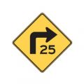
Turn Advisory
-
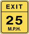
Exit Advisory
-
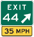
Exit Sign Plaque


Special speed limits
As of February 2016[update], the WME and Waze App only support maximum speed limits for passenger vehicles, without variation for time of day, or day of the week. Specialty, also known as 'bannered' speed limits, like the ones shown below, should NOT be added to the Waze map.
-
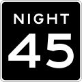
Night Speed
-
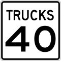
Truck Speed
-
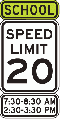
School Speed
-
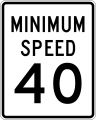
Minimum Speed


| School zone speed limits that are in effect 24 hrs per day, and 365 days a year, should be added to the map. |
Where speed limits change
How far from an existing junction not to a new a cut. ~ minimum 200' maximum 1000'.