(TBSL) |
|||
| Line 99: | Line 99: | ||
== Where speed limits change == | == Where speed limits change == | ||
Speed limits should change where they legally go in effect for your state, that may be at the sign, a specified distance before the sign, or the nearest intersection; check your [[#Regional and state local wiki|local wiki]] for the practice in your area. When a speed limit changes in the middle of a segment, {{u|a new junction should added to support the SL change}}. | |||
* However '''a new junction should never be added for a SL if it will be within 200 feet of an existing junction''', or potential junction. | |||
* Depending on your [[#Regional and state local wiki|local guidance]] this distance may be expanded above 200 feet, always confirm local practice. | |||
* A new junction should always be added if it will be more than 1,000 feet from the nearest existing, or potential junction. | |||
=== Creating a new junction for a speed limit change === | |||
When creating a new junction solely for the sake of showing a speed limit change, you can attempt to get more value from the junction. Survey the area around the speed limit change, determine if there is a PLR or other segment which should be connected to the road and would result in a junction. You may find that there's a parking lot which could benefit from being added to the map within the allowable distance of 200 feet (or more depending on your area) to where the SL changes. In such a case connect that segment and use that junction. Otherwise you should create a new junction to show where the SL changes. | |||
== Regional and state local wiki pages == | == Regional and state local wiki pages == | ||
Revision as of 10:55, 21 February 2016
Speed limit (SL) data added to segments in the WME is used in the Waze client app to display a Wazer's speed relative to the speed limit. In addition, the app alerts Wazers if they exceed the speed limit designated on the Waze map.
This article discusses When, How, and Which speed limits should be added to the map in the USA. The guidelines set forth below may be expanded by local regional or state guidance, Please be sure to check your local wiki for any relevant information as well.

Which speed limits should be added to the map
The ONLY speed limits added to the map are Regulatory Speed Limits. These must match federal, state, and municipal laws or regulations that designate enforceable maximum speeds for passenger vehicles. These are marked with black lettering on white rectangular signs.
Fixed regulatory speed limits
Any fixed (non-variable) speed limits posted on the regulatory black and white signs should be added to the road corresponding segments in the WME.
Ramps
If there is a regulatory speed limit sign posted on the ramp itself, this speed limit should be added for the ramp segments.
If the speed limit for the segments on either end of the ramp are the same, then that limit should be added to the ramp as well.
| Ramps with only advisory speed limit signs, as shown below, should have no speed limit in the WME. |
At grade connectors
AGCs follow these 3 basic rules in this order of preference (apply first match):
- If it has its own dedicated posted regulation SL, use it.
- If the SL before and after are the same, use it
- If it physically looks and functions as a ramp, leave it blank, otherwise use the SL of the segment feeding into the AGC (s-in)
Private
Speed limits that are designated on private property using regulatory signs may be added to road segments on the Waze map at the discretion of the Regional Coordinator or State Managers. Be sure to check your local wiki for guidance.
| Speed Limits are added to parking lot and private road types by changing type to street, adding limits, then reverting to the original road type. |
Work zones


Speed limits in work zones are often lowered to protect workers and prevent collisions. If these speed limits appear on regulatory black and white signs, they MAY be added to the associated WME road segments, IF supported by your local area. However, this should be done in consultation with State Managers or Regional Coordinators, so that the temporary speed limits can be monitored for changes. It may be prudent to only modify the speed limit for long-term construction projects, each region must decide what terms are best locally.
Another option is to add the underlying to speed limit to the map for now, and put the work zone speed limit in a specially marked UR note (or otherwise keep track of it). Being that as of the writing of this page[update] the speed limit feature is not yet functional in the production client app, this will prevent redundant effort to go back and fix the speed limits if the construction ends before the speed limit feature is rolled out.
Check your regional or state wiki to see which work zone limits should be added in your area, and the process for monitoring them.
Click [show] below for links to your wiki.
| |||||||||||||||||||||||||||||||||||
Variable Speed Limits

The WME and Waze app do not support Variable Speed Limits (VSLs) that are changed based on traffic and road conditions. These VSLs can be changed at any time by government officials. If there is a 'standard' speed limit at which the signs on a stretch of road are set for the majority of the time, this 'standard' speed COULD BE added to the associated road segments in the WME. However, the setting of any speed limit on a road with VSLs must be made in consultation with the appropriate State Manager, or Regional Coordinator.
Time based speed limits
As of February 2016[update], the WME and Waze App only support a single speed limit, without variation for time of day, or day of the week. Segments with time based different speed limits should use the speed limit which is in effect the majority of the time (most hours of the day, days of the week).
For example let's assume a 35mph street has a reduced speed limit of 20mph for the hours of 7am-4pm School Days. Then it is not in effect every single day, and even the days it is in effect, it's only for 9 hours. The rest of the time the 35mph limit is in effect. This segment should be set to the 35mph limit.
Unsupported speed limits
The following speed limits are unsupported by the WME and the Waze app, and MUST NOT be added to road segments in the WME. Road segments with posted 'advisory' speeds or special speed limits should continue the Speed Limit for passenger vehicles as posted on the black and white signs pictured above.
Advisory speed limits
In addition, yellow 'advisory' speed signs (as shown below) are usually not enforceable; therefore, 'advisory' speeds, like the ones shown below, should NOT be added to the waze map.
-

Advisory Plaque
-
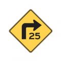
Turn Advisory
-
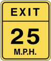
Exit Advisory
-
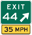
Exit Sign Plaque


Special speed limits
As of February 2016[update], the WME and Waze App only support maximum speed limits for passenger vehicles, without variation for time of day, or day of the week. Specialty, also known as 'bannered' speed limits, like the ones shown below, should NOT be added to the Waze map.
-
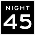
Night Speed
-
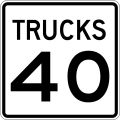
Truck Speed
-
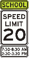
School Speed
-
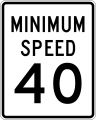
Minimum Speed


| School zone speed limits that are in effect 24 hrs per day, and 365 days a year, should be added to the map. |
Where speed limits change
Speed limits should change where they legally go in effect for your state, that may be at the sign, a specified distance before the sign, or the nearest intersection; check your local wiki for the practice in your area. When a speed limit changes in the middle of a segment, a new junction should added to support the SL change.
- However a new junction should never be added for a SL if it will be within 200 feet of an existing junction, or potential junction.
- Depending on your local guidance this distance may be expanded above 200 feet, always confirm local practice.
- A new junction should always be added if it will be more than 1,000 feet from the nearest existing, or potential junction.
Creating a new junction for a speed limit change
When creating a new junction solely for the sake of showing a speed limit change, you can attempt to get more value from the junction. Survey the area around the speed limit change, determine if there is a PLR or other segment which should be connected to the road and would result in a junction. You may find that there's a parking lot which could benefit from being added to the map within the allowable distance of 200 feet (or more depending on your area) to where the SL changes. In such a case connect that segment and use that junction. Otherwise you should create a new junction to show where the SL changes.